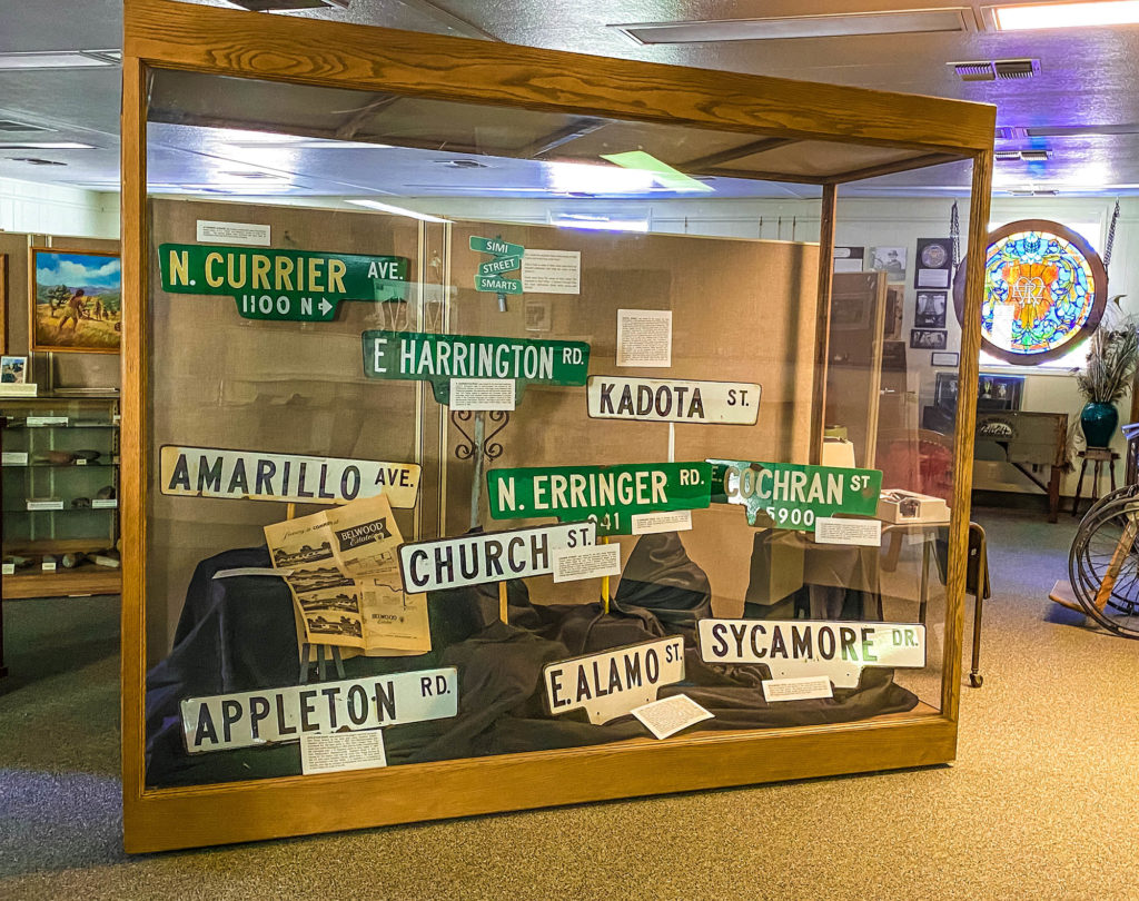
The Streets of Simi Valley
Why is ‘Los Angeles Ave.’ called that? Why is there a street called ‘Runway?’ Some streets were simply named by a developer. Some have really interesting reasons and stories behind their names. Learn more about the origins of the street names in Simi Valley.
Los Angeles Ave.
LOS ANGELES AVENUE: has been in existence for a long time! The Simi Land and Water Company included Los Angeles Avenue on their maps as early as 1887-1888 when they began to subdivide. The street was called Los Angeles Avenue, because it was the main route from the center of Ventura County (Los Angeles Avenue begins in Saticoy) since the Spanish Land Grant era. Later it also became known as Highway 118. Did you know that in the mid 1970s there was an attempt to change the name of Los Angeles Avenue to ‘Santa Susana Boulevard?’ The attempt did not succeed primarily because citizens, business owners on the thoroughfare, and long time residents protested.
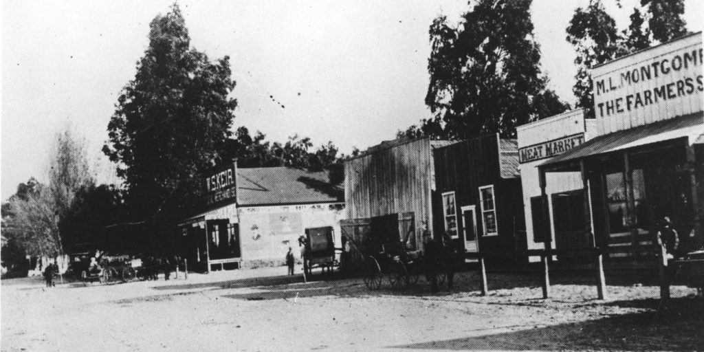
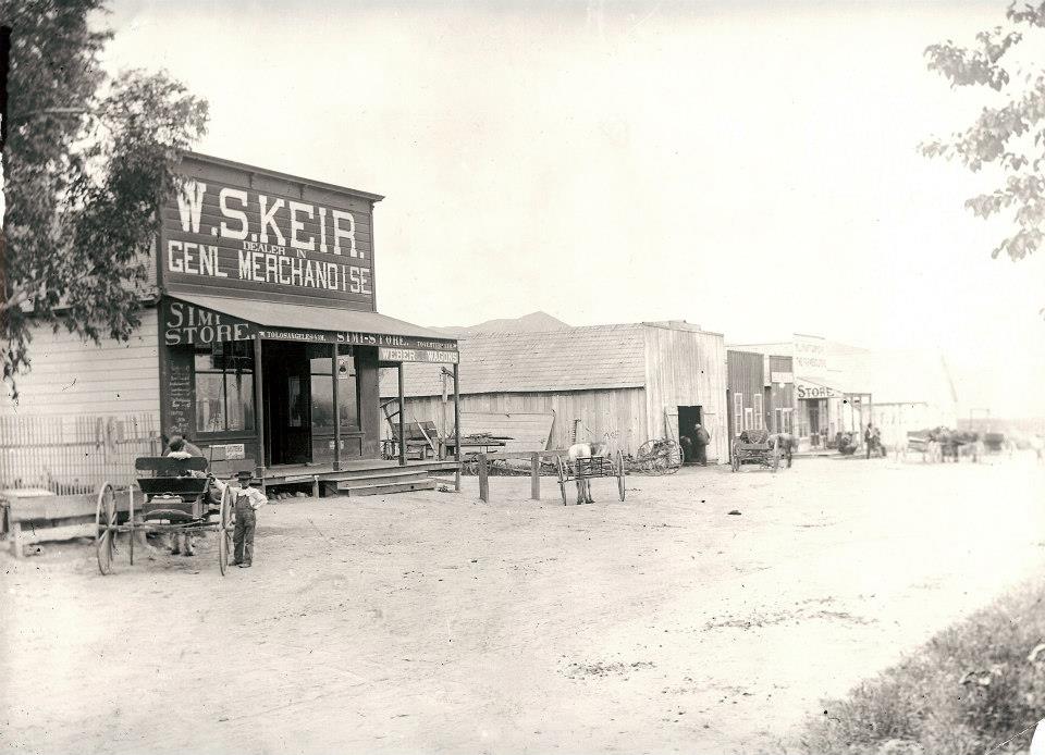
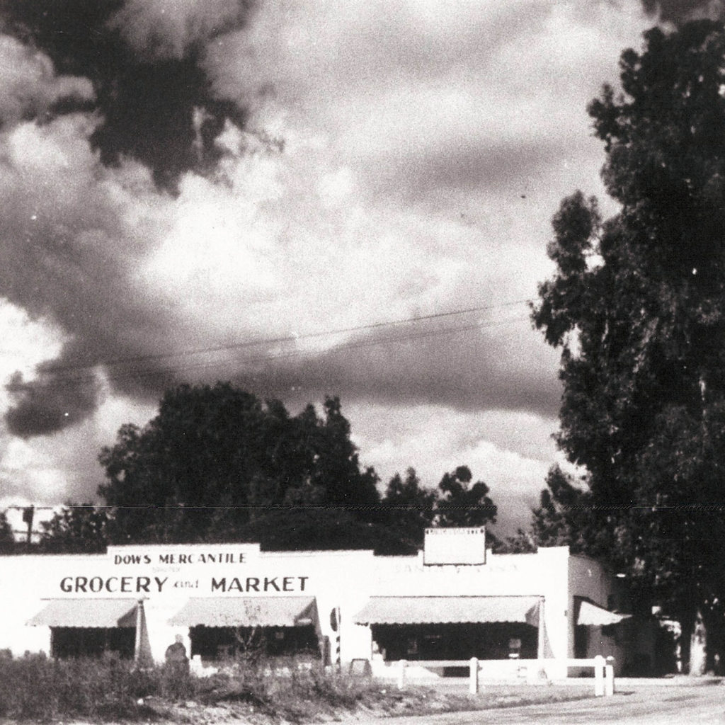
This photo is a view of the main business district on Los Angeles Ave. of the Simi Colony looking southeast.
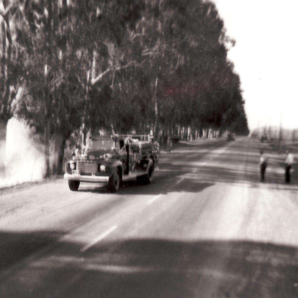
A later photo of Los Angeles Avenue…this one shows firefighters extinguishing a fire that broke out along eucalyptus trees on the south side of LA Avenue near Sycamore Drive (c1949 -1955).
Royal Ave.
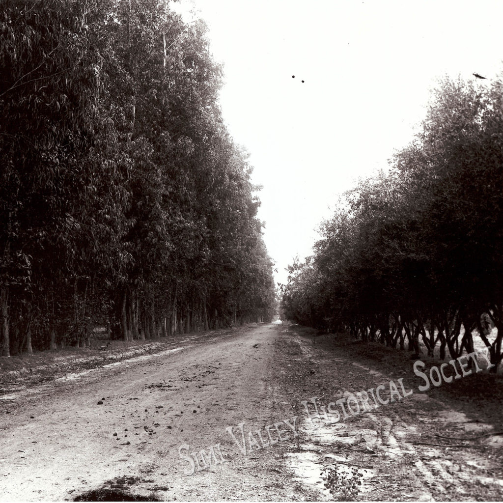
ROYAL AVENUE: From what is now First Street to Madera the current Royal Avenue was known as ‘Pitts’ because that was the name of the family who owned the land there. Patricia Havens remembers catching the bus on the ‘corner of Kujawsky and Pitts’ when she lived on the ranch where the Wood Ranch development is now. There are a few stories about how Royal got its name. It used to be called ‘the back road.’ One story is that Elliot Harrington named it because he thought the name ‘Royal’ was more fitting for his horse named Queen than ‘the back road.’ Another theory is the route which is now Royal Avenue was sometimes used as the ‘Camino Real.’ Real means ‘Royal’ in Spanish. Another more simple explanation is that the name comes from the Royal Variety of apricots which were grown in the area. This photo of Royal Ave. was taken around 1908. this photo shows Royal Ave. looking West toward Erringer Road.
Appleton Rd.
APPLETON ROAD: was named for the wagon road that ran south from Royal Avenue to the John Sparhawk and Laura Appleton Ranch. J. S. Appleton came to Simi Valley in 1887 from Newburyport, Massachusetts and purchased the 160 acre ranch in 1891 from Charles Hoar. The ranch was sold to developers in 1962, and the Griffin Company built the Stonegate tract on the land. J. S. Appleton is considered a pioneer, and was an amateur photographer who lived and farmed in Simi Valley for most of his life. It is due to him that we have so many outstanding photos of our past.
Valley Fair
Did you know that Valley Fair used to be called something else? When that area was the town of Santa Susana, Valley Fair was known as First Street. When Simi and Santa Susana grew, and just before they incorporated under the name ‘Simi Valley,’ the name of ‘First St.’ in Santa Susana changed to ‘Valley Fair’ because there couldn’t be two ‘First Streets’ in the community…it got too confusing. This building is still standing on Valley Fair. It was Simi’s first ‘Strip Mall’ built by Louis Riave in the 1920s. Looking north over the railroad tracks. The building now houses ‘Aubergine Emporium.’
Runway St.

Do you know why this street is called Runway St.?
Runway at former Santa Susana Airport

It was the runway for the Santa Susana airport. This is an early view of the Santa Susana airport looking in a westerly direction.
Church St.
CHURCH STREET: was named for the Simi Valley Methodist Church, which was built in 1924 and dedicated January 18, 1925 under Pastor Ralph W. Lee. The architectural design of the building was modeled after a church in Whittier, CA. The building is Greco-Roman in style and designed by L.A. architect Arthur G. Londley. The City of Simi Valley purchased the building in August 1991. It was remodeled, and the 280 seat Simi Valley Cultural Arts Center was opened November 2, 1995.
Alamo St.

ALAMO STREET was originally Palm Avenue or Drive. The row of palm trees were planted as the south border of the Patterson Ranch Company development c1913 according to Joe Schreiber, who worked for the Tapo Mutual Water Company from its beginning in 1918 until its closure c1967. There are more than 140 Washingtonia filifera palms along Alamo. A few of the trees were moved around the corner to Tapo Canyon Road during modernization/addition of the DMV, etc. Alamo does not mean palm in Spanish (it means poplar). “Palma” means palm. No one has a good reason for the name change.
E ALAMO STREET the East-West division was likely based on the separation of the town of Santa Susana located on the East end of the valley and the town of Simi on the Westside. This division continues to be evident in the East-West division of the postal codes 93036 (east), and 93065 (west), divided at the location of the US Post Office at Galena Street.
More Street Names
TEXAS AVENUE: Located in the ‘Texas tract.’ All of the names in the tract are named for locations in Texas. The ‘Texas Tract’ as the housing development is known by Simi Residents was built in 1961-1964. The west part of it was built by the Alscot development company and is called the ‘Belwood Estates,’ and the east part of it was built by Alpine homes and was called the ‘Simi Hills Estates.’ The dividing line seems to be Big Springs Ave.
E COCHRAN STREET: was named for president W. G. Cochran of Simi Land and Water Company, which first subdivided the Simi Valley in the late 1880s. Cochran Street extended west only to the present Tapo Canyon Road during farming days. In order to cut across to deliver the mail, Charlie Havens would have to take his shovel to move sand so he could get through via a “short cut” rather than drive a longer distance.
N CURRIER AVENUE: the modern subdivision used the pioneer family same of R.J. “Doss” and Rebecca Currier for one of its streets.
N ERRINGER ROAD: John R. Erringer was one of the early landowners under Simi Land and Water Company. Along with Jonathan P, Green, he owned the 2,780 acre parcel B at the south side of the valley.
FITZGERALD ROAD runs west from Appleton Road to the Fred Fitzgerald ranch that was located where the present Hillside Junior High School is now situated.
HARRINGTON ROAD: was named for the Harrington brothers. John P. Harrington was an anthropologist who worked for the Smithsonian Bureau of American Ethnology doing fieldwork with indigenous peoples. His interviews with the Chumash people living near Simi Valley helped to preserve the Chumash culture and language, which both enabled modern anthropologists to produce books in the Chumash language and created a resource for their descendants. His brother, Robert E. Harrington lived in Simi Valley and wrote a local history, “Early Days of Simi Valley,” which was published in 1961.
INGRAM TRACT STREET NAMES: In the spring of 1947, a developer named Richard F. Ingram bought property from Pacific States Savings and Loan and placed it on the market. It was a chance for buyers to buy small acreage and build their own homes with several operating chicken/egg ranches in that area. PATRICIA STREET was named after the Ingram daughter. GALT, CHARLES, WILLIAMS and HUBBARD were named for early purchasers of the land.
KADOTA STREET: was named for the Kadota Fig Farm development, a 1920s land sale scheme of Los Angeles based W. F. Loomis. He bought the former Justin Petit property on both sides of Tapo Street, planted several hundred acres of Kadota figs, and divided it into acre lots. He named the streets Adam, Eve, Apricot, Barnard, Kadota, and Fig. Potential buyers were told that if they purchased 2 acres, each including 65 fig trees, they could make a living from the figs. Loomis sold the lots for the enormous price of $2,800 per acre, but promised that buyers would also be included in profits from his oil well at the northwest corner of Tapo Street and Alamo [near the site of the current Tapo Transmission & Automotive], as well as his business raising young squabs (baby pigeons), which were popular in restaurants at the time. The well never actually produced oil, but was “pumped on Sundays” after being primed for potential customers. Baker Browning had a “Demonstration acre” on the northwest corner of Cochran and Tapo Streets, where all the wonders of the development were available for the gullible city folks, many of them professionals from Los Angeles. A few of the buyers stayed permanently: Elvina and Joe Johnson, Hattie and Ted Hansen, Alma and Ben Stark, the Johnsons whose sons were named LeRoy and Ovrville, and others.
KUEHNER DRIVE: the only hint as to Kuehner’s origin was provided when “someone knew someone” named Kuehner who once worked at the Douglas Recreation Ranch north of the current 118 freeway, east of “Indian Hills’. At one time the Douglas ranch raised numerous hogs, partly to supply their cafeterias, and this person possibly worked on the hog ranch (as per docents Barbara and Jim Gobble, 1994) [Hoar Street, shown as a zigzag road named for owner Charles E. Hoar, was still being used as the road to the Hummingbird’s Nest Ranch from Los Angeles Avenue on a 1932 precinct map.]
MADERA ROAD: was known as Kujawsky Road. The Kujawsky family owned the Ranch that the road ran to and through. Eventually the Wood Family came to own what we now call Wood Ranch. After the death of her husband, Mrs. Wood petitioned the county to change the name of the street from Kujawsky to ‘Madera’ which means wood in Spanish.
PEPPERTREE LANE: Lined with pepper trees, this long straight road led from Los Angeles Avenue all the way south to the Eddie Maier Ranch. The square-shaped Maier House was built about 1912, around an atrium (the house no longer exists due to the 1994 earthquake). In the 1940s, the ranch was acquired by the Brandeis Institute, and eventually the adjacent Jim Arness ranch was donated to Brandeis also. When the road was improved to accommodate the burgeoning modern industrial complex, the pepper trees, said to be old and diseased, were removed. Tapo Canyon Road was finally extended across the railroad tracks, and aligned with the old Peppertree Lane in 1993, and the name Tapo Canyon superseded Peppertree Lane. Now “Peppertree Lane” begins at the entrance to American Jewish University (Brandeis/Bardin Institute), and is still lined with its original, ancient pepper trees. There is also a short “Peppertree Lane” in Susana Knolls which goes west from the west loop of Katherine Road, just south of the railroad tracks not far from Black Canyon Road.
TAPO: Tapo came from the Chumash word ‘Ta’apu’ which we thought meant ‘yucca,’ but that turned out not to be the case. We don’t know what “Ta’apu’ meant in the Chumash language. We know that it was the name of the largest Chumash village which was in the area. The reason we have ‘TAPO CANYON’ AND ‘TAPO STREET’ is because in the days where there weren’t paved roads, and ranches dominated the landscape, Tapo Street went from the town of Santa Susana to Alamo, people would then just cut across fields and continue on to Tapo Canyon. When the official roads were laid out the two Tapos were separated.
TIERRA RAJADA ROAD (with an “a”) shows on the diseño (Spanish map) of El Rancho Simi. When it was changed to Tierra Rejada with an “e” is not known. Whether it is a corruption of “roja,” and related to the red color of stones in the area, or to crack or fissure (canyon or valley?), as “rajar” means “to split, rend, crack,” is not known. It was definitely named in early Spanish rancho days.
WALNUT STREET: was likely named for the many walnut orchards, which flourished in the Mediterranean-like climate of Simi Valley.
SYCAMORE DRIVE: this was a narrow, barely paved road north from Los Angeles to the ranches in the area east and west of it, and to the Tapo District. The logical conclusion would be some relation to trees, though usually sycamores grow near water, and the original Sycamore Drive had no such trees.
Learn more about The streets of Simi valley! The Appendix in Simi Valley – A Journey Through Time has this information about street names…and MORE!